simple is beautiful
NYC Taxi Photo: January 2008
2 ... 2 ...

Tuesday 29 January 2008

Friday, 12-28-07

I've been a little behind, 
but this is the last of the pictures from last year.

I highly recommend clicking on each picture to get a larger window


Chelsea 
The party people had come and gone in Chelsea and elsewhere. 
As a man cleans the curb for coming day's business.


Upper East Side
There is a time in the morning where dawn gives 
faint enough light to see our streets, yet the 
lights from inside buildings still poke through.


Gramercy


Chelsea
Somehow these two got into an accident strong enough 
to deploy the airbags. Apparently there are over 
5,000 doctors in NYC if you have healthcare.


--------------------------------------
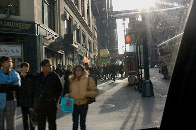
42nd Street pedestrian survey east bound:


Friday 25 January 2008

I lost my marbles:

"A Quinnipiac University poll released earlier this month showed 

that 58 percent of New York City voters opposed Bloomberg's congestion pricing plan, with 37 percent supporting it and the rest undecided. 

But 60 percent said they would support the proposal if it generated money to improve mass transportation, with 37 percent opposing."

No Folks, you can't make this shit up. Is it just me of does it feel like I'm trapped in an episode of a satirical cartoon?

Thursday 24 January 2008

12/16/07

Pictures posted in Chronological order during the shift of 12/16/07:

Williamsburg, Brooklyn

Sunnyside, Queens

Williamsburg Bridge

Lower East Side

Little Italy

SoHO

Somewhere Manhattan

Battery Park City

Sunnyside, Queens

Rockefeller Center

Downtown

Gramercy

Friday 18 January 2008

12/29/07


Mott Haven, The Bronx


Lower East Side


East Village


Gramercy


SoHo
Does anybody know where the Firefighter Museum is? I took people here, because their tourist map said it was around here, Spring between West Broadway and Wooster, but I couldn't find it even after turning off the meter and driving around the block. SoHo seems like an odd neighborhood for the Firefighter Museum.


Lower East Side
This is the same corner shown earlier, 
only in the day time. Rumor has it a Starbucks will open here.

Lower East Side

Down Here Below

A newbie to New York, Steve Earle, Has written this beautiful song that I'm hooked on. It is a song from an old time New Yorker's perspective, and I'm not sure how he got it so right.

Ignore the DJ who has no place on that stage.


He's even got a stanza refering to exactly what I was talking about in earlier posts:

Now Hell’s kitchen’s Clinton,  Bowery’s Nolita
And the East Village keeps on creepin’ ‘cross the Williamsburg Bridge
Hell, whatever happened to Alphabet City?
Ain’t no place left in this town that a poor boy can go


There are a few small issues. There is obviously more than one Red Tailed Hawk in the city, the one in Central Park gets all the fame. In fact I have even seen wild turkeys in Manhattan. Well I also saw a nude man picking crap out of his own ass, but that's beside the point. 

I had no idea who Joe Mitchell was, another reference in the song so Here's the Wiki page for Joseph Mitchell

Thursday 17 January 2008

The Map!

Totally sorry, but this map is even better, than the ones I mentioned before. 

Click on the link, then click on specific sections for detailed street names and neighborhood distinctions.

District Profile Map


The only problem with this, is that certain zoomed in neighborhood maps are turned upside down, and clockwise, etc.. etc..


Gucci Gucci Gucci

December 29th

September 30th

June 3rd

I don't know about you, but I like seeing these giant ads play with scale. It's a pity that at some point this will be another overpriced store that sells crap to suckers.

Wednesday 16 January 2008

A good neighborhood map

I think I found one finally:


Click a zone number to see the neighborhoods within. There are still a bunch of neighborhood names not mentioned, but its pretty decent.

The best map I've found for a specific borough was here: Queens Boundaries

This is the best map I could find for Manhattan: NYC, Manhattan

Half of Brooklyn, is known only to the veteran New Yorker, and not very well I might add, so there are no good maps specifically for this entire borough. The only maps I could find for Brooklyn only cover the left side of it.

12/30/07 Sunday

Oh it's been a while since I posted (new) photos. The last day I drove in 2007, I only got 2 good pictures out of a whole 10 or so. So it was less overwhelming for me to look through such a little amount of shots. I think I came down with a slight fever this week.

Chelsea, I guess you kinda figured that out. For some reason hot dogs and tropical fruit drinks go well together I guess.

Linden Hill ,Brooklyn

This place is fricken' awesomely creepy. I recommend never dropping off anybody here. I gotta be honest with you, 30% of the time I don't know the name of the neighborhood I am in. I have never even heard of Linden Hill. And yet I have routinely driven through this desolate place as a short cut to get to the Williamsburg Bridge from Bushwick and Ridgewood. In this neighborhood only warehouses exist. Sometimes I see the remnants of compact cars or sport utilities which have been burned almost beyond recognition. The police regularly cruise the empty streets with spot lights aiming in corners and their headlights off. The neighborhood still keeps busy in certain spots with the pungent aroma of municipal waste, as trucks are guided over abandoned train tracks. If anyone makes a regular habit of commuting through here, they tend to own sport utility vehicles with better suspension to handle the potholes and the train crossings.

A while ago I knew someone who rented out a loft with a few of his friends here. The deal was the whole neighborhood was zoned for industrial use, and therefore the loft was illegally rented, and cheaper. But if there was any problem with the landlord, the tenants could all be kicked out. The inspections were a real hassle too, not to mention the loneliness of the neighborhood.

Neighborhood distinction:

It is hard to know what neighborhood has what name, because there are so many names, and a lot of neighborhoods expand into the territory of other neighborhoods. The real-estate market has it's own set of rules for creating names and taking names away as well. Each map puts different names in different places. 

Williamsburg is ever so popular, and so almost all of Bushwick is being called Williamsburg. Chinatown has expanded so large it has taken over almost all of Manhattan's Little Italy, and more of the Lower East Side as well. Hell's Kitchen is only referred to orally or for historical and sensational merit. The maps will either refer to it as Clinton or the Far West Side. The Far West Side is actually south of Hell's Kitchen in my opinion, just a name reserved for a neighborhood with nothing but taxi garages and the convention center. But some refer to the area south of Hell's Kitchen or Clinton as Chelsea. In this northern Chelsea is also the plant or flower district, and the fashion or garment district. NoLita, is some cooked up real-estate term for North of Little Italy. NoHo, is North of Houston Street, but just like NoLita, it should be conglomerated into the larger surrounding neighborhood. SoHo is South of Houston, but that designation And the TriBeCa (Triangle Below Canal) have been around long enough to be real neighborhoods. There are neighborhoods within neighborhoods. Downtown, Lower East Side, Greenwich Village, Harlem, and Uptown, are larger generalities where other neighborhoods reside. As far as Brooklyn and Queens, there are so many neighborhoods, I still don't know where they all fit in.

Any questions? I know I have a few

Monday 14 January 2008

The Second Avenue Deli returns

We New Yorkers have grown accustomed to establishments which make our city special, closing and being replaced by big corporate chains. 

Ahhh, finally, good news. The Hungry Cabbie reports, The 2nd Avenue Deli has re-opened, though it is no longer in the East Village, or on 2nd Ave.